
11.10.15
The Tower (SK 141 914)
 |
| The Tower (SK 141 914) |
When Aled and I were
revaluating The Fours for Europeaklist publication I can remember accessing
on-line information on The Tower and gazing at photographs of this rather
beautifully steep hill, that although smaller in height when compared to its
moorland neighbours it still dominated its immediate surroundings. This sense of domination is seldom visualised
in a hill of lesser height, but this hill is rather special and today we
planned on visiting it.
The Tower which is also
known as Alport Castle is situated north of the busy A 57 as it thunders
between Manchester and Sheffield. There
is sufficient parking for two or three vehicles at SK 141 895 on the south side
of the road just before Alport Bridge when approaching from the west. This parking area is conveniently positioned
opposite a path that gains height to a track that makes its way toward Alport
Farm, and this is probably the easiest ascent route if just wanting to visit this
hill.
There was a stillness in
the air as we started our walk and the day’s forecast was good, at this time of
year when seasonal change occurs high cloud can give a friendly blanketing
effect to the land, however conditions can change quickly and high cloud can
dissipate leaving radiant sunshine, and as we walked up the track past an
avenue of small trees there were glimmers that the cloud would break and blue
sky would burst through.
 |
| Walking through the avenue of trees toward Alport Farm |
The track leading to
Alport Farm is positioned above the River Alport and gives an elevated vantage
point across to The Tower, but its steep sided profile is obstructed by the
higher moor land plateau which is situated immediately behind it. This partly obstructed view was tantalising
as it looked inviting but its detail could not be picked out.
As we lost height toward
the farm and down to the river the jagged summit of The Tower bust up out of
its immediate background, it looked impressive.
We crossed the river on a slender but robust footbridge and as we gained
height on a good path on the eastern side of the river I looked back toward the
farm and there was a line of people heading toward the footbridge. This was a group from The Priory Academy and
Lincoln Minster School on their Duke of Edinburgh award scheme, they had
previously forded the River Ashop and then walked past us as we were getting
our boots on and the customary good mornings were exchanged, we then past them
as they were taking a well-earned break on the path leaving the A 57 and which
gains the track toward the farm.
 |
| Our first view of the jagged summit tors of The Tower |
 |
| On our way down to the River Alport |
 |
| Crossing the river |
 |
| On their Duke of Edinburgh award scheme and passing Alport Farm |
The green path leading
up beyond the footbridge was a delight as patches of blue sky were now
appearing and autumnal bracken shone out with dulled browns interspersed
amongst golden greens and yellows, by now the group from Lincoln were quickly
catching up with us, they past us at a brisk pace with smiles and waves and all
carrying horrendously large packs and disappeared out of view above. Our progress was more leisured as we were in
no rush and we rested for a few minutes whilst John picked a variety of field
mushrooms and happily munched away on them for his early dinner.
 |
| John heading up toward The Tower |
 |
| Figures on the escarpment edge give perspective to the scene with the upper part of The Tower bathed in sunshine |
Continuing upward we
soon came across the group sitting down enjoying the brightening conditions, we
stopped and chatted for a few minutes and then watched them as they shot off
again to the moor land above.
 |
| The group from The Priory Academy and Lincoln Minster School |
 |
| And away they go..... |
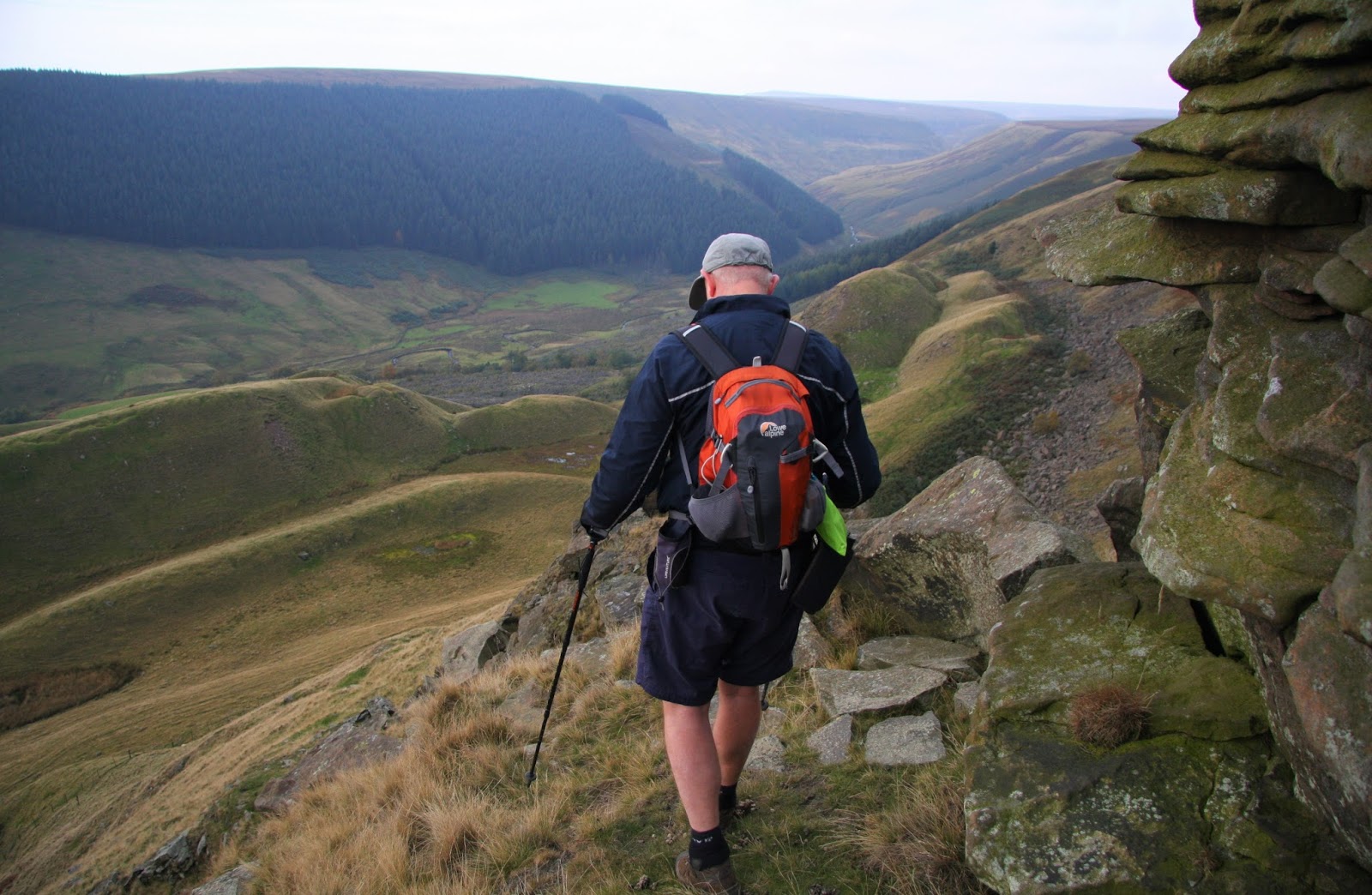
Our route now left the
main path and headed direct toward The Tower which looked even more impressive
the closer we were getting to it, it looked as if it had three granite tors at
its summit; their profile suggested they would require a hard scramble to get
to the top.
I’d made a note of the
ten figure grid references of the two positions that Ordnance Survey maps
indicate could be the position of this hill’s critical col, which Mark had
input in to his hand held GPS earlier in the walk. As John strode out toward the first option
for this hill’s col, Mark examined his GPS and we were still about 200 metres
away from the first set of co-ordinates.
However, where John was standing was certainly one col possibility and
we made a note to survey it on our descent.
 |
| Inputting the ten figure grid references. Photo: John Kirk |
On the eastern side of
The Tower is a boulder field indicating that this area can become a wee bit
hazardous on occasion as huge slaps of rock are dislodged from the hill itself
or from the higher cliffs of the near escarpment edge.
John led the way as we
gained height on steep grass to the slender grassed ridge that heads directly
toward the southern base of The Tower, it was here that we found another col,
this was enclosed by rock and as I set the Trimble above the col and took a measurement
offset we inspected our surroundings, and there was consensus that this col was
much higher than the one that we had just left, as both were on the hill to
hill traverse this one could be dismissed, however as the Trimble was set-up I
took data anyway, and as it beeped away collecting its 300 data points Mark and
John continued steeply uphill.
 |
| John making progress on the steep grass |
 |
| On the narrow grass ridge |
 |
| Gathering data from the first of four positions surveyed for the critical col with the Trimble placed 1.64m above the point of this particular col |
As the Trimble gathered
its first set of col data I looked up and John and Mark were on steep grass
making progress toward a small band of rock, John was leading and on occasion
it looked as if his face was hugging the ground in front of him as the route up
was so steep.
Once five minutes of
data were collected I took a few photos, packed the equipment away and started
to scamper uphill as fast as I could, Mark was already waving back at me from
the summit and John was waiting beside the small rock band.
 |
| Mark nearing the summit |
 |
| John at the rock band |
Continuing upward I got
over the one small rock step and grabbed grass in front of me as I heaved my
way up and then popped out at the summit, Mark was happily sitting on top of
the highest rock tor and I soon found myself on the adjacent lower tor looking
over at Mark and taking a few photographs, as I placed the viewfinder to my eye
the world took on a decidedly uncomfortable wobbly nature and my legs seemed to
turn to the proverbial jelly, this only happened when the camera was against my
eye, it is an experience I’ve had before and one that only happens when perched
above a drop on a narrow platform.
 |
| Mark at the summit |
As a breeze was blowing
and the drop from the high point would mean certain Trimble death I started to
sort out the Trimble’s dog collar, it’s never been dressed up in its chain and
collar before, and I have fond memories of the ten minutes spent in my local
pet shop as I and the assistant tried a variety if leashes on the Trimble, an
experience that no doubt does not happen in the pet shops of this world on
every day of the week.
I attached the chain to
the elasticated grip underneath the Trimble and hooked this on to the dog lead
which I placed through one of my rucksack straps; the rucksack was then placed
in a convenient niche in the rock tor which was below the height of the
summit. Happy that the Trimble would be
saved from certain oblivion if the wind blew it over I set it up aligned with
the high point of the tor and sat under my rucksack on a rock seat and waited
for the five minutes of data to be gathered.
Once complete I took a series of photographs, none of which would do
justice to its position, and packed it and its dog lead away. This system had worked perfectly well and
gave me peace of mind, so in the future there will be no occurrences like those
on the summits of Glyder Fach and The Stiperstones where I watched in horror
and counted down the seconds hoping that the poor Trimble was secure on the
rock and would not be toppled to an uncomfortable end on the ground below.
 |
| Gathering data at the summit of The Tower |
 |
| The system of attaching the Trimble to my rucksack via a chain and dog lead worked extremely well and I'll use it again when faced with the next precarious summit |
We left the summit of
The Tower and negotiated the one rock step and continued down its steep grassy
slopes to the narrow grass ridge below, meeting an exquisite yellow frog on the
way who happily posed for a number of photos before bouncing off in to the
grass.
 |
| Heading down from the summit of The Tower |
 |
| Negotiating the rock step |
 |
| Back on the narrow grass ridge |
 |
| The beautiful yellow frog |
The next point to survey
was the first option for the connecting col that we had reached on our
ascent. As the Trimble gathered its
allotted five minutes of data sat on top of my rucksack elevated 0.49m above
the ground, John and Mark headed in to the boulder field at the eastern base of
The Tower, where another option for this hill’s col was situated.
 |
| Gathering data from what turned out to be the critical col of The Tower |
 |
| John and Mark in the boulder field assessing the ground for the next col placement |
 |
| The stunning profile of The Tower |
By now a dappled cloud
scape was set against blue sky and our surrounds were magnificent as we were in
a bowl between The Tower and the high escarpment edge. After packing the Trimble away I scampered
off to join John and Mark who had inspected this latest col position and as I
arrived they indicated where the Trimble should be set up. As it beeped away collecting its data points,
I sat and looked up at The Tower, now straight above me it looked somewhat
daunting.
 |
| Gathering data at the third col placement |
Again, John and Mark
continued around the eastern side of the hill and soon John called back that
there was another col to its north, these col options are difficult to pinpoint
on the map as a ring contour where the boulder field appears on the ground is a
depression and not an elevation as usually expected.
 |
| John standing above the last of the col placements |
Once the Trimble had
been packed away I threw myself across the rock and scampered down and then up
to join John who was standing just above this latest col option, as I set the
Trimble up John sauntered off and Mark waited just below this col for the Trimble
to do its stuff.
 |
| Gathering data at the fourth col placement |
As we contoured around
the western side of The Tower and headed toward our inward path the sun bathed
down from a dapple clouded beautiful blue sky.
The colours now accentuated in the bracken made for a lovely gentle
descent with the afternoon light now lower, giving an autumnal brilliance to
the scene. Crossing the river the land
shone in autumn refinement, this is such a special time of year as seasons
change and coloured life ebbs in to winters chill.
 |
| Our last view of the jagged tors at the top of The Tower |
 |
| Autumn's beauty |
 |
| The tranquil River Alport |
We followed the path
back toward the farm and picked a few dry mouthed slow berries on the way. The eastern hillsides enclosing the River
Alport rose in afternoon colour as their opposing and western hillsides ran
down in shadow.
 |
| Mark on the path back toward Alport Farm |
It had been a great day
on the hill, capped with a visit to what must be one of the best of The
Fours. As we made our way down the
inward track I stopped and framed Mark and John walking through the avenue of
small trees, a moment in time captured as had been the memory of our walk.
 |
| Back through the avenue of small trees |
Survey Result:
The Tower
Summit Height: 458.2m (converted to OSGM15)
Summit Grid Reference: SK 14111 91445
Col Height: 420.1m (converted to OSGM15)
Col Grid Reference: SK 14207 91320
Drop: 38.1m
Dominance: 8.32%
Dominance: 8.32%
For further details please
consult the Trimble survey spreadsheet click {here}
No comments:
Post a Comment